How Space Technology Is Helping Farmers Stay Ahead of Locusts, Armyworms, and Mites
A few years ago, I spoke with a regional crop advisor after a tough season. Fall armyworm had spread quickly through several maize-growing areas. What stood out was not just the damage, but how quickly it happened.
“We didn’t miss it,” he told me. “It just moved faster than our monitoring system.”
That comment sums up the challenge farmers face today. Pest outbreaks are not new, but what has changed is their speed, scale, and unpredictability. Weather patterns shift, rainfall comes in bursts, and warmer conditions let insects survive longer. By the time crop damage is visible, controlling it is harder and more costly.
This is why AI-based pest outbreak detection with satellite images is gaining attention. It provides farmers with advance notice, a rare advantage.
The Growing Problem of Pest Outbreaks
Across continents, pest pressure is intensifying.
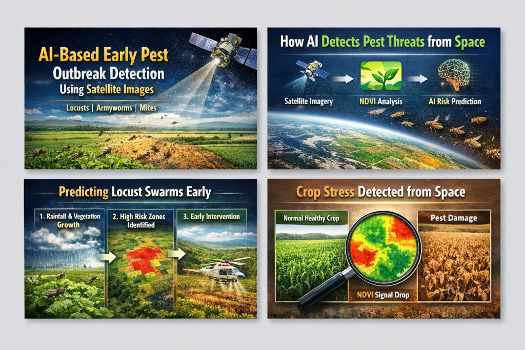
Desert locusts multiply rapidly after rainfall in arid regions. Once swarms form, they travel across borders in days.
The fall armyworm spreads aggressively and feeds on staple crops such as maize and sorghum.
Mites develop quietly, weakening plants before obvious symptoms appear.
Traditional monitoring depends on field scouting, farmer observation, and extension reports. These methods are useful, but they have limits. You cannot check every hectare every day, and early stress signals are not always visible to the naked eye.
That’s where remote sensing and artificial intelligence come into play.
What Satellite Imagery Really Detects
Satellites in agriculture do more than just take pictures. They measure how light bounces off crops at different wavelengths, including those our eyes cannot see.
Healthy crops reflect light differently from stressed crops. Even small changes in leaf colour or shape can change how light is reflected. Tools like NDVI help turn these differences into measurable indicators of plant health.
For example:
- A sudden drop in vegetation vigour may signal feeding damage.
- Increased soil moisture in dry regions may indicate ideal conditions for locust breeding.
- Persistent heat patterns may accelerate pest life cycles.
These signals often appear before farmers see widespread damage in the field.
Satellites detect the effects pests have on plants, not the insects themselves. This difference is important.
How AI Turns Data into Risk Warnings
Satellite data by itself does not predict outbreaks. Artificial intelligence looks for patterns over time and links them to historical records.
Machine learning models are trained using:
- Past locust swarm data
- Confirmed armyworm infestation zones
- Climate and rainfall records
- Soil moisture trends
- Crop growth stages
Over time, the model identifies environmental combinations that tend to precede outbreaks.
For instance, locust risk increases when heavy rainfall in dry zones triggers rapid vegetation growth. Armyworm activity often occurs within specific temperature and humidity ranges during specific crop stages. Mite outbreaks coincide with prolonged hot, dry spells.
Instead of only reacting, AI-based systems anticipate where pest problems may arise.
This ability to predict makes a big difference.
To ensure these predictions help in real-world farming, careful model evaluation is critical.
Before these systems are used widely, researchers carefully test their reliability.
Desert Locust Prediction
Locust monitoring models focus on rainfall, vegetation growth, and soil moisture in historically vulnerable areas. Researchers compare predicted risk zones with actual swarm reports.
Evaluation looks at:
- How accurately were high-risk areas identified
- Whether alerts were issued early enough to act
- Whether targeted interventions reduced losses
In several recent outbreaks, early satellite-driven monitoring enabled authorities to concentrate resources where breeding was most likely to occur.
Fall Armyworm Detection
Armyworm feeding creates recognisable stress signatures in maize fields. AI models trained on satellite imagery are validated using field inspections.
Researchers measure:
- Detection accuracy across seasons
- Performance across different crop varieties
- Consistency under varying weather conditions
In practice, early alerts have helped extension services guide farmers toward targeted scouting rather than blanket spraying.
This approach lowers costs and helps prevent using too many chemicals.
Mite Monitoring Through Vegetation Stress Analysis
Mite infestations are harder to detect remotely because the symptoms resemble drought stress.
To make results more reliable, researchers use satellite data alongside drone imagery and manually inspect crops. AI models learn to distinguish between plants that need water and those stressed by pests.
Checking conditions on the ground is still essential. Satellite data is most useful when combined with local observations.
Why This Technology Matters
From field discussions and published research, three practical advantages stand out.
Earlier Intervention
Even a few days of advance notice lets farmers step up monitoring and take action before an infestation spreads.
Smarter Chemical Use
Instead of treating whole fields, farmers can focus on specific high-risk areas. This saves on pesticide costs and is better for the environment.
Better Agricultural Planning
Governments and agencies can deploy limited response teams strategically when outbreak risk is clearly mapped.
For regions already facing food insecurity, this is especially important.
Challenges Still Facing AI-Based Pest Detection
Despite progress, the system is not perfect.
Cloud cover can block satellite data. Small infestations might not quickly change how plants look from above. Some areas also do not have enough historical data to train AI models well.
Communication is another challenge. Farmers need clear advice, not complicated technical details. Turning data into useful guidance is still a key step.
Technology helps agriculture, but it does not replace the experience of farmers.
Looking Ahead
The future of early pest outbreak detection will likely involve stronger integration between satellite imagery, drone monitoring, ground sensors, and farmer-reported observations.
Instead of using separate tools, agriculture may soon use connected monitoring networks that update risk levels all the time.
Getting a local warning about higher armyworm risk before any damage is visible would change how decisions are made.
This kind of early warning helps build resilience.
Final Thoughts
AI-based early detection of pest outbreaks using satellite images is a major step forward in helping farmers manage risks.
It helps us spot environmental warning signs, judge the chance of an outbreak, and respond before problems get worse.
For farmers, it means more time to act.
For policymakers, it strengthens food security strategies. For agriculture as a whole, it adds accuracy where uncertainty was common. In summary, AI-based early detection offers timely alerts, targeted interventions, and better planning at all levels.
In farming, timing often determines success.
When technology provides earlier warnings, results improve. Early detection is the key takeaway: it means faster response, less loss, and stronger farming outcomes.